
Home > Store > marine_electronics > navionics
|
|
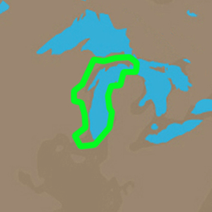
C-MAP 4D NA-D931 Lake Michigan 1/24
C-MAP
C-MAP 4D NA-D931 Lake Michigan
SHIPS FREE IN LOWER 48 STATES
The next evolution in navigation solutions. C-MAP 4D adapts to your boating
needs because it's the only digital chart that offers advanced features and
lets you add data and services as they become available.
Full 4D Content
When you choose Full 4D content you will experience the latest in navigation
data and technology such as:
- 3D Chart View - The world has three dimensions.
When you add the 4th dimension of time - meaning consistent, periodic
updates - you combine the most detailed 3D height and depth worldwide
database with a continuous update process to give you a personalized
navigation experience with up-to-date data for safe navigation.
- High-Resolution Satellite Imagery - See the real world on your
screen.
C-MAP 4D includes a navigational perspective with high-resolution coastal
imagery overlaid on the most accurate and up-to-date vector data, plus
thousands of extraordinary photos for the most popular marinas and areas of
interest.
- Digital Raster Charts - Innovate tradition.
With raster charts, you have an additional reference source for navigational
awareness. Get "at-a-glance" information using the nautical paper charts
overlaid on the multi-dimensional shaded relief to have a new visual
experience.
- Easy Routing - Automatically create a route.
Enter start and end points along with specific boat parameters and
automatically receive waypoints of the shortest route; highlights potential
hazards and displays varying levels of alerts for each segment of the route,
allows you to manually adjust the route.
- Guardian Alarm - An extra layer of safety.
When activated, Guardian Alarm performs an automatic forward-scanning check
for obstacles. Use the feature as an added backup to alert you should you
head toward a potentially harmful object.
- Detailed NavAids
- Route Check
- Detailed Marina Charts
- C-Marina Ports Database
- Multi-Language Capability
- Dynamic Tides & Currents
- Photos & Diagrams
- Depths & Land Elevations
- Perspective View
4D cartography is compatible with the Furuno 1670F / 1870F, and Standard CPN 7000i, and CPN1010i UNITS
|
Click for larger image

|
|
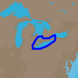
C-MAP 4D NA-D933 Lake Erie and Lake St Claire 1/24
C-MAP
C-MAP 4D NA-D933 Lake Erie and Lake St Claire
SHIPS FREE IN LOWER 48 STATES
The next evolution in navigation solutions. C-MAP 4D adapts to your boating
needs because it's the only digital chart that offers advanced features and
lets you add data and services as they become available.
Full 4D Content
When you choose Full 4D content you will experience the latest in navigation
data and technology such as:
- 3D Chart View - The world has three dimensions.
When you add the 4th dimension of time - meaning consistent, periodic
updates - you combine the most detailed 3D height and depth worldwide
database with a continuous update process to give you a personalized
navigation experience with up-to-date data for safe navigation.
- High-Resolution Satellite Imagery - See the real world on your
screen.
C-MAP 4D includes a navigational perspective with high-resolution coastal
imagery overlaid on the most accurate and up-to-date vector data, plus
thousands of extraordinary photos for the most popular marinas and areas of
interest.
- Digital Raster Charts - Innovate tradition.
With raster charts, you have an additional reference source for navigational
awareness. Get "at-a-glance" information using the nautical paper charts
overlaid on the multi-dimensional shaded relief to have a new visual
experience.
- Easy Routing - Automatically create a route.
Enter start and end points along with specific boat parameters and
automatically receive waypoints of the shortest route; highlights potential
hazards and displays varying levels of alerts for each segment of the route,
allows you to manually adjust the route.
- Guardian Alarm - An extra layer of safety.
When activated, Guardian Alarm performs an automatic forward-scanning check
for obstacles. Use the feature as an added backup to alert you should you
head toward a potentially harmful object.
- Detailed NavAids
- Route Check
- Detailed Marina Charts
- C-Marina Ports Database
- Multi-Language Capability
- Dynamic Tides & Currents
- Photos & Diagrams
- Depths & Land Elevations
- Perspective View
|
Click for larger image
|
|
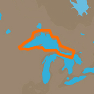
C-MAP 4D NA-D930 Lake Superior 1/24
C-MAP
C-MAP 4D NA-D930 Lake Superior
SHIPS FREE IN LOWER 48 STATES
The next evolution in navigation solutions. C-MAP 4D adapts to your boating needs because it's the only digital chart that offers advanced features and lets you add data and services as they become available.
Full 4D Content
When you choose Full 4D content you will experience the latest in navigation
data and technology such as:
- 3D Chart View - The world has three dimensions.
When you add the 4th dimension of time - meaning consistent, periodic
updates - you combine the most detailed 3D height and depth worldwide
database with a continuous update process to give you a personalized
navigation experience with up-to-date data for safe navigation.
- High-Resolution Satellite Imagery - See the real world on your
screen.
C-MAP 4D includes a navigational perspective with high-resolution coastal
imagery overlaid on the most accurate and up-to-date vector data, plus
thousands of extraordinary photos for the most popular marinas and areas of
interest.
- Digital Raster Charts - Innovate tradition.
With raster charts, you have an additional reference source for navigational
awareness. Get "at-a-glance" information using the nautical paper charts
overlaid on the multi-dimensional shaded relief to have a new visual
experience.
- Easy Routing - Automatically create a route.
Enter start and end points along with specific boat parameters and
automatically receive waypoints of the shortest route; highlights potential
hazards and displays varying levels of alerts for each segment of the route,
allows you to manually adjust the route.
- Guardian Alarm - An extra layer of safety.
When activated, Guardian Alarm performs an automatic forward-scanning check
for obstacles. Use the feature as an added backup to alert you should you
head toward a potentially harmful object.
- Detailed NavAids
- Route Check
- Detailed Marina Charts
- C-Marina Ports Database
- Multi-Language Capability
- Dynamic Tides & Currents
- Photos & Diagrams
- Depths & Land Elevations
- Perspective View
|
Click for larger image
|
|
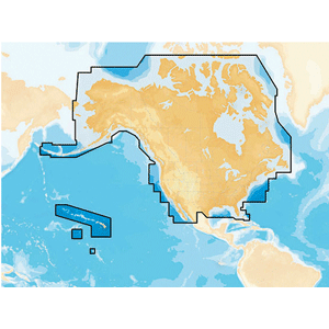
Navionics NAUS001L - U.S. & Coastal Canada - Navionics+ 1/24
Navionics
Navionics+ Preprogrammed with All USA/Canada Gold and Hot Maps Data in MSD Format
SHIPS FREE IN LOWER 48 STATES
NAUS001L - U.S. & Coastal Canada - Navionics+
Get
the world’s No. 1 choice in marine mapping - with the best, most
up-to-date Navionics+ cartography on your compatible chartplotter.
For
offshore or inland waters, this all-in-one solution offers detail-rich
integrated mapping of coastal waters, lakes, rivers and more. Get
SonarChart™ 1’ (0.5 meter) HD bathymetry maps, advanced features such as
dock-to-dock route guidance technology, live mapping and Plotter Sync
to provide wireless access to daily updates.
The Navionics Chart
Installer software also ensures the freshest chart data every time out.
Navionics dock-to-dock route guidance solutions give you a suggested
path to follow through channels, inlets, marina entrances and more.
Multiple shading options aid in shallow water navigation and make it
easy to highlight a target depth range for the best fishing spots.
Chart Code - NAUS001L
Coverage Area:
Coverage
of the entire U.S. coasts, lakes, rivers and inland waterways, plus
Alaska and Hawaii. Canada coverage of coastal British Columbia, the
Great Lakes, the St. Lawrence Seaway, New Brunswick and Nova Scotia.
Coverage includes Bermuda, the Bahamas, Baja California, the Gulf of
California, Johnston Atoll and Palmyra Atoll/Kingman Reef.
Features:
- Nautical
Chart – Comprehensive charts are derived from multiple officials,
government, and private sources, displayed in a familiar look and feel
- SonarChart
HD Bathymetry - Innovative 1' (0.5 m) bathymetry charts are created by
using Navionics proprietary systems that augment existing content with
sonar data contributed by the boating community
- Community Edits -
Get useful local knowledge from edits made by users of the Navionics
Boating app on your compatible smart device.
- Daily Updates - Up to 5,000 daily updates to our charts give you the most accurate, most current Navionics data available.1
- Dock-to-dock Route Guidance2 - Start your trip with a suggested path.
- SonarChart Live Mapping - Watch new HD depth maps develop in real-time as your boat moves through the water.
- Advanced Map Options - Customize your view to focus on the details that matter most
- Plotter Sync1 - Transfer routes and markers, update chart layers, and more - between your compatible chartplotter and the Boating app.
Compatibility:
- Check the compatibility of Navionics+ content and features with your GPS chartplotter.
Technical Specifications:
In the Box:
1Subscription
not required for SonarChart Live mapping feature on some chartplotter
models; requires latest chartplotter firmware release.
2Dock-to-dock Route Guidance is for planning purposes only and does not replace safe navigation operations.
*Navionics+ and Platinum+ cards are not compatible with Garmin chartplotters.
*Sold as an Individual
This
product may not be returned to the original point of purchase. Please
contact the manufacturer directly with any issues or concerns.
|

Click for larger image
|
|
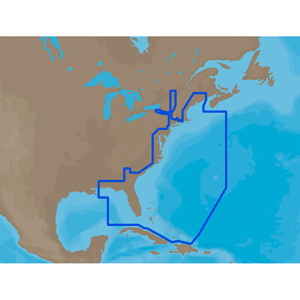
U.S. East Coast & The Bahamas - C-Card =C-MAP MAX NA-M022 1/24
C MAP
NA-M022 => USA East Coast and Bahamas
SHIPS FREE IN LOWER 48 STATES
Coverage of the United States Atlantic coast from Passamaquoddy Bay, ME down to Key West, FL, with extended coverage into the Gulf of Mexico over to Perdido Bay, FL. Includes coverage of Bermuda and all of the Bahamas. Also includes coverage of the Hudson River, Lake Champlain, Erie Barge Canal, Savannah River, St John's River and Okeechobee Waterway. Caribbean coverage includes charts from Explorer Chartbooks and Wavey Line Publising
|
Click for larger image
|
|
|
|
|
|


;)
;)
;)
;)
;)

