
Home > Store > marine_electronics > other_electronics
|
|
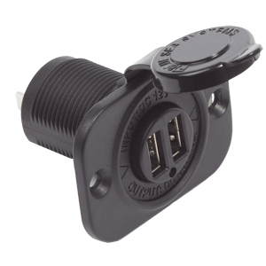
USB Charger Socket Blue Sea Dual - 2 USB Ports w/Watertight Cap 1/24
Blue Sea Systems
Dual USB Charger Socket
SHIPPING INCLUDED TO LOWER 48 STATE DESTINATIONS
Conveniently Charge Popular USB-Powered Mobile Devices
Protective cap with tether keeps dust and spray from shortening the life of the charger. Made with materials which ensure a solid contact and low voltage drop.
Blue Sea's 1016 Dual USB Charger Socket is easy to install in an existing 12 VDC socket hole providing convenient access for charging mobile devices.
Includes:
- 2 USB ports
- Watertight cap
Features:
- Watertight cap
- Corrosion resistant materials
- Protected from overheating
- Easy installation
Specifications:
- USB: 2.0
- Input Voltage: 12V-24V DC
- Output Voltage: 5V DC +/- 5%
- Max. Output Current: 2.1A DC
- Cut Out Dimensions: 1-3/16" Dia.
- FCC Part 15: Subpart B Compliant
|
Click for larger image

|
|
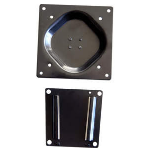
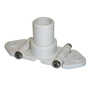
Wall Mount Bracket w/2-Piece Slide Majestic 1/24
Majestic
Wall Mount Bracket with 2-Piece Slide
SHIPPING INCLUDED TO LOWER 48 STATE DESTINATIONS
Simple wall plate for easy fitting & removal
Majestic LA7C is a simple wall bracket designed to work with both 75mm and 100mm Vesa. Simply lift and the TV comes off, and to mount it just slide it on.
Accessories Supplied: Bracket with Screws
Color: Black
Features: Easily removable
Features: Can be used in multiple locations with extra LA10M
Screen Size (Diagonal): 10" to 22" Majestic
Vesa Size: 75mm or 100mm
- Accessories Supplied Bracket with Screws
- Color Black
- Features Easily removable
- Features Can be used in multiple locations with extra LA10M
- Screen Size (Diagonal) 10" to 22" Majestic
- Vesa Size 75mm or 100mm
|
Click for larger image
|
|
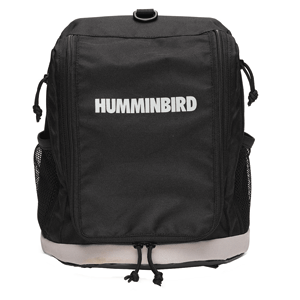
Humminbird ICE Fishing Flasher Soft Sided Carrying Case 1/24
Humminbird
CC ICE
780015-1
SHIPPING INCLUDED TO LOWER 48 STATE DESTINATIONS
Soft-sided carrying case. (No shuttle, battery, or charger)
|
Click for larger image
|
|
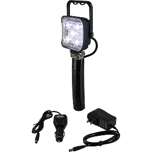
LED Rechargeable Handheld Flood Light - 1200 Lumen 1/24
SEA DOG
LED Rechargeable Handheld Flood Light - 1200 Lumens
SHIPPING INCLUDED TO LOWER 48 STATE DESTINATIONS
This
marine grade LED Rechargeable Handheld Flood Light features five 3W
high intensity Bridgelux LEDs which produce 1200 lumens. Fully
adjustable, the handle allows the light to be hung or propped at many
different angles to illuminate the task at hand. Includes both a 12VDC
and 120VAC charge adapter. Constructed of a black powder coated aluminum
housing with a stamped 304 stainless steel bracket and polycarbonate
lens. 7.4V 2200mAh rechargeable Li-battery. Run time 3-4 hours. Charging
time 3-4 hours. IP65 rating. CE, RoHS compliant.
|
Click for larger image
|
|
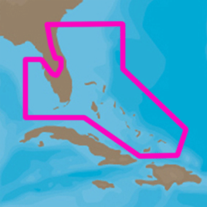
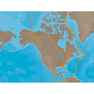
C-MAP 4D NA-D943 Florida & The Bahamas 1/24
C-MAP
C-MAP 4D NA-D943 Florida & The Bahamas
SHIPS FREE IN LOWER 48 STATES
The next evolution in navigation solutions. C-MAP 4D adapts to your boating needs because it's the only digital chart that offers advanced features and lets you add data and services as they become available.
Full 4D Content
When you choose Full 4D content you will experience the latest in navigation data and technology such as:
- 3D Chart View - The world has three dimensions.
When you add the 4th dimension of time - meaning consistent, periodic
updates - you combine the most detailed 3D height and depth worldwide
database with a continuous update process to give you a personalized
navigation experience with up-to-date data for safe navigation.
- High-Resolution Satellite Imagery - See the real world on your
screen.
C-MAP 4D includes a navigational perspective with high-resolution coastal imagery overlaid on the most accurate and up-to-date vector data, plus thousands of extraordinary photos for the most popular marinas and areas of interest.
-
Digital Raster Charts - Innovate tradition. With raster charts, you have an additional reference source for navigational awareness. Get "at-a-glance" information using the nautical paper charts
overlaid on the multi-dimensional shaded relief to have a new visual experience.
-
Easy Routing - Automatically create a route. Enter start and end points along with specific boat parameters and automatically receive waypoints of the shortest route; highlights potential hazards and displays varying levels of alerts for each segment of the route, allows you to manually adjust the route.
- Guardian Alarm - An extra layer of safety. When activated, Guardian Alarm performs an automatic forward-scanning check for obstacles. Use the feature as an added backup to alert you should you
head toward a potentially harmful object.
- Detailed NavAids
- Route Check
- Detailed Marina Charts
- C-Marina Ports Database
- Multi-Language Capability
- Dynamic Tides & Currents
- Photos & Diagrams
- Depths & Land Elevations
- Perspective View
4D cartography is compatible with the Furuno 1670F / 1870F, and Standard CPN 7000i, and CPN1010i units.
|
Click for larger image
|
|
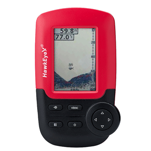
HawkEye FishTrax™ Handheld Fish Finder w/HD Color VirtuView™ Display 1/24
Hawkeye
HawkEye FishTrax™ Handheld Fish Finder w/HD Color VirtuView™ Display
SHIPPING INCLUDED TO LOWER 48 STATE DESTINATIONS
Fish From Anywhere™ Dock, Bridge, Shoreline, Boat, Kayak, Canoe, Ice Anywhere Your Tackle Box Can Go, the FT1PXC Can...
The Go Anywhere, Do Anything, Fish Finder...
FishTrax intelligent sonar delivers precise fish finder readings up to 240'. Audible fish alarm signals the presence of fish. VariableZone water temperature sensor shows water temperature throughout the water column. Weed and rock indicators indicate bottom composition. Glare-Free icon LCD with LED backlight offers excellent readability. EasyTouch user interface makes system setup and adjustment easy. The FishTrax 1C comes with a Airmar transducer that is float-able, troll-able or can be boat mounted, that way you know you are getting an unmatched, go anywhere portable device. We know how important it is to have as much space on your kayak, canoe or dinghy as possible, that is why the FishTrax 1C runs off of 4 AAA batteries. Giving you at least 30 hours of battery life. Which means there is no need to have a heavy battery pack installed in your kayak, canoe or dingy taking up all your precious room. Leaving you with more room for other gear. To Use: Simply turn the power on, toss the unique floating sonar sensor from the shoreline, bridge, or boat and instant depth, fish, weed, and bottom contour readings are now in the palm of your hand.
Features:
- FishTrax™ Intelligent Sonar Delivers Precise Fish FinderReadings up to 240'
- Audible Fish Alarm Signals the Presence of Fish
- Adaptive Software Programming Minimizes False Readings
- VariableZone™ Water Temperature Sensor Shows Water Temperature Throughout The Water Column
- Weed and Rock Indicators Indicate Bottom Composition
- Glare-Free Icon LCD with LED Backlight offers Excellent Readability
- EasyTouch™ User Interface Makes System SetupAnd Adjustment Easy
- Airmar Transducer is Trollable, Boat Mountable, & Floatable... Achieves Unmatched, Go Anywhere, Portability(*)
- Built-In Expandability Allows Addition of Accessories To Adapt To Any Fishing Platform
- Sonar Sensor Side-Scan Adapter Allows Sonar Direction Finding Under Weeds, Docks, Ice, etc
- Includes User Friendly Color Coded Operation Manual and Free Access to a 24 Hour Online Technical Support Center
- Industry Leading 2 Year Warranty
(**) For the depth and fish sonar features of this unit to function properly, the sonar sensor must be in direct contact with the water or a boat hull as per the instructions in the operator's manual. Readings are NOT obtainable through the air.
How To Catch More Fish With HawkEye® Fish Finders
Adjust the Sensitivity:
Adjusting the amount of detail the shown on the VirtuView™ display is as simple as adjusting the fish finder's sensitivity. There are 10 user selectable sensitivity settings to choose from. Select a higher sensitivity setting to show smaller sonar returns on-screen, or a lower setting to remove clutter from the screen. Adjusting Sensitivity also affects how sonar returns are identified as fish icon symbols - more fish will be detected at a higher setting, fewer at a lower setting.
Use the Fish Alarm:
You can set the FishTrax™ 1 to sound an audible alarm when a group of fish are detected. Turn it on, and when a fish passes under the sonar sensor, an audible alarm will sound. You can then use the fish depth scale to drop your bait to a depth that will get it in front of the fish. Leave the alarm on if you are using a crank bait so that you do not have to steadily watch for fish on the screen. If you hear the alarm, gently toss your bait at least 20 feet beyond the sonar sensor, allow the bait to drop to the depth of the fish alarm, and retrieve as recommended for the targeted species.
Maximize Side-Scanning
Here are some ideas for maximizing the usefulness of the Side Scan Adapter: Attach it to a dock piling and scan sideways for fish swimming by. Attach it to a boat, kayak, or canoe hull and slow troll for fish, all the while keeping a look out for fish behind or in front of you. Attach it to a broom stick handle and search for the best fishing location. Attach it to a broom stick and seek out the fish hiding away from your fishing hole while ice fishing.
Broom Stick Side-Scanning
By attaching the optional Side-Scan Adapter to an ordinary broom stick or paint roller handle purchased from a local hardware store, you can scan for fish suspended in the water column within 240'(75M) of your location. Attach the sensor to a handle, lower the sensor into the water, and slowly move the sensor in a manner that will allow the signal to search the desired location (a sweeping motion similar to using a flashlight is most effective). Keep in mind the sonar signal is emitted from the base of the sensor. Scan down, sideways, or any combination of the two. Remember, to get depth and bottom contour and composition readings you will have to aim the signal at a solid object within 240' (75M), however FISH readings will be accurate, even if the depth reading is "---"
|
Click for larger image
|
|
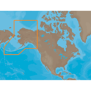
C-MAP MAX NA-M028 - Alaska - SD™ Card 1/24
C-MAP
NA-M028 Alaska
Coverage of the southern Alaska coast from Dixon Entrance up and over to Kodiak Island. Includes all of the Aleutian Islands out to Attu Island, Bristol Bay, and the North Slope over to Liverpool Bay in the Yukon Territory, Canada. Additional coverage of the MacKenzie River down to the 1160 km distance marker.
|
Click for larger image
|
|
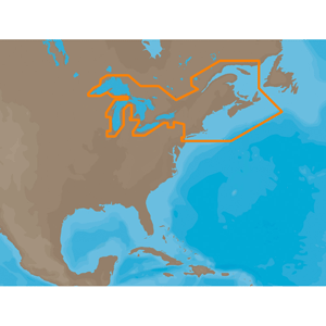
C-MAP MAX NA-M026 - Great Lakes & The Maritimes - C-Card 1/24
C-MAP
NA-M026 => Great Lakes, Northeast Coast and Approaches
SHIPS FREE IN LOWER 48 STATES
Coverage of the Great Lakes, St. Lawrence River and Northeast United States. Coverage of the Great Lakes also includes Fox River and Lake Winnebago, Lake St. Clair, Rideau Canal, Ottawa River and the Trent-Severn Waterway. Includes all coastal charts for New Brunswick and Nova Scotia in Canada and Maine, New Hampshire, Massachusetts, Connecticut and New York in the U.S. Also included is coverage of the Hudson River and Lake Champlain as well as the Erie Barge Canal.
|
Click for larger image
|
|
C-MAP CARD ATLANTIC COAST, Gulf OF MEXICO & CARIBBEAN - SD™ Card C-MAP MAX NA-M033 1/24
C-MAP
NA-M033 => Atlantic Coast, Gulf of Mexico and Caribbean
SHIPS FREE IN LOWER 48 STATES
Coverage includes most of the eastern coastline of North America. Canadian coverage starts in Arctic Canada and continues east to Hudson Bay, Ungava Bay and Frobisher Bay before continuing south down the Labrador coast to Newfoundland, the Gulf of St. Lawrence and Nova Scotia. The St. Lawrence River is covered down to Montreal. US coverage picks up at Passamaquoddy Bay and heads south down the Atlantic coast, picking up all of Chesapeake Bay, and continuing down to Key West, FL before turning into the Gulf of Mexico. The Gulf of Mexico, from Key West, FL to Brownsville, TX is covered in its entirety. Latin America is covered from the Mexico/US border over around the Yucatan Peninsula along the coasts of Belize, Honduras, Nicaragua, Costa Rica and through the Panama Canal before turning north up the Pacific coastline to Salina Cruz, Mexico. All the islands of the Caribbean are covered, from the Bahamas over to Cuba, east to the Virgin Islands and down to Grenada. The Caribbean coasts of Colombia and Venezuela are also covered, from Golfo de Uraba in Colombia over to the Rio Orinoco delta in Venezuela. Coverage of Bermuda is also included.
|
Click for larger image
|
|
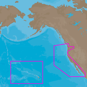
C-MAP 4D NA-D024 - USA West Coast & Hawaii - Full Content 1/24
C MAP
NA-D024 - U.S. West Coast and Hawaii
Full 4D Content
SHIPS FREE IN U.S.A.
When you choose Full 4D content you will experience the latest in navigation data and technology such as:3D Chart View - The world has three dimensions.
-
When you add the 4th dimension of time - meaning consistent, periodic updates - you combine the most detailed 3D height and depth worldwide database with a continuous update process to give you a personalized navigation experience with up-to-date data for safe navigation.
-
High-Resolution Satellite Imagery - See the real world on your screen. C-MAP 4D includes a navigational perspective with high-resolution coastal imagery overlaid on the most accurate and up-to-date vector data, plus thousands of extraordinary photos for the most popular marinas and areas of interest.
- Digital Raster Charts - Innovate tradition. With raster charts, you have an additional reference source for navigational awareness. Get "at-a-glance" information using the nautical paper charts overlaid on the multi-dimensional shaded relief to have a new visual experience.
-
Easy Routing - Automatically create a route. Enter start and end points along with specific boat parameters and automatically receive waypoints of the shortest route; highlights potential hazards and displays varying levels of alerts for each segment of the route, allows you to manually adjust the route.
- Guardian Alarm - An extra layer of safety. When activated, Guardian Alarm performs an automatic forward-scanning check for obstacles. Use the feature as an added backup to alert you should you head toward a potentially harmful object.
- Detailed NavAids
- Route Check
- Detailed Marina Charts
- C-Marina Ports Database
- Multi-Language Capability
- Dynamic Tides & Currents
- Photos & Diagrams
- Depths & Land Elevations
- Perspective View
|
Click for larger image
|
|
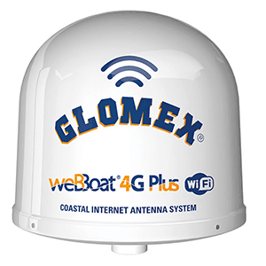
Glomex Dual SIM 4G/WIFI All-In-One Coastal Internet System - webBoat® 4G Plus for North America 1/24
GLOMEX
Dual SIM 4G/WIFI All-In-One Coastal Internet System - webBoat® 4G Plus for North America
SHIPPING INCLUDED TO LOWER 48 STATE DESTINATIONS
The WeBBoat® 4G Plus is the first and award-winning COASTAL INTERNET
4G/3G/Wi-Fi DUAL SIM integrated system to surf the web. The system
ensures stable and high-speed connections up to approximately 20 miles
from the coast. The WeBBoat® 4G Plus is equipped with four 4G/3G
diversity antennas, two diversity Wi-Fi antennas, and a super-fast
3G/4G/Wi-Fi router that creates a hot spot on the vessel. Up to 32
different devices can be used simultaneously without any degradation to
the signal or performance. The unit's built-in advanced switching
software allows the user to save money on costly roaming and overage
charges by automatically switching to Wi-Fi when available.
The
WeBBoat® 4G Plus is a true Plug & Play device that requires minimal
setup and only one power lead for the antenna which operates from 10-30
VDC. The Dual-SIM architecture allows the user to have more choices for
operation (i.e. different carriers for coverage, extra data if one card
runs out, etc). weBBoat® 4G Plus EVO has additional features such as
automatic APN, SMS management/reading/sending to monitor internet
consumption, automatic switching mode with onboard satellite internet
devices/V-SAT and an encrypted real-time peer-to-peer connection for
remote set-up and service that increase the performance and usefulness
of your integrated system Coastal Internet.
Installations:
- Sail Boat
- Power Boat
- Big Yacht
Specifications:
- Antenna dimensions (diam.x H): 250 x 300 mm/10x12"
- Antenna weight: 1,2 kg/2,65 lb
- DUAL MINI SIM system
- Automatic switch Wi-FI registered networks to 4G automatic APN
- SMS management function
- V-SAT/SAT internet autoswitch mode
- Switching cellular data to external Wi-Fi
- Encrypted real-time peer-to-peer connection for remote set-up and service
- 4G backup WAN function
- LTE 4G up to 150 Mbps in download
- DC- HSPA+ up to 42 Mbps in download
- Power Supply: 10/30 Vdc
- Average Consumption: 150mA
Data:
- Mode LTE: DL 150 Mbps
- DC-HSPA+: DL 42 Mbps
- Complies with IEEE 802.11n, IEEE 802.11g, and IEEE 802.11b wireless
- 4 Ethernet ports (1 WAN + 3 LAN)
- 4 Diversity (high) performance antennas
- 2 High Gain Wi-Fi antennas
- SMS reboot function
- Android and iOS App for an easy control
- Easy installation requires only a power supply connection 12/24V
- UV resistant Dome
OPTIONAL ACCESSORIES:
 |
 |
|
70221 MOUNT
|
70222 MOUNT
|
|
|

Click for larger image

|
|
|
|
|
|


;)
;)
;)

;)
;)
;)
;)
;)
;)
;)
;)

